By Infoaxis Weather Desk
Columbia, SC — A series of multiple severe thunderstorm alerts have been issued across large parts of South Carolina in recent weeks, as volatile weather systems have repeatedly swept through the state. These alerts — issued by the National Weather Service (NWS) and communicated through various media, cell alerts, and apps — reflect an active spring and early summer severe weather season marked by strong storms capable of producing damaging winds, hail, heavy rain, power outages, and even tornadic activity.
This piece from Infoaxis, provides an in‑depth look at the nature of the storms, the counties affected, impacts on communities, and guidance for residents during such severe weather outbreaks.
Meteorological Setup: Why These Storms Are Forming
The repeated severe thunderstorm alerts across South Carolina are not random events. Meteorologists point to a well‑defined weather pattern responsible for the storm clusters:
- Warm, moisture‑laden air from the Gulf of Mexico and Atlantic Ocean provides abundant fuel for storm energy.
- Cold fronts and upper‑level disturbances create atmospheric instability as they move across the Southeast.
- Enhanced wind shear and strong jet stream dynamics help thunderstorms organize and intensify.
When these ingredients converge — warm surface air, moisture, lift from a cold front, and wind shear — conditions become favorable for severe thunderstorms, which can develop rapidly and trigger warnings across multiple counties. This setup was noted in a recent analysis highlighting a powerful cold front colliding with a humid air mass in South Carolina, causing multiple severe thunderstorm alerts across broad regions of the state.
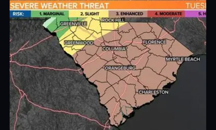
Counties Under Alert and Times of Impact
Over the past months, alerts have been issued repeatedly for vast swaths of South Carolina:
The Midlands and Central South Carolina
Areas such as Richland, Lexington, Sumter, and Orangeburg Counties have been placed under severe thunderstorm watches and warnings on numerous occasions as storm lines move through central parts of the state. The Midlands, which includes the state capital Columbia, has at times seen significant weather impacts including wind damage and flooding.
The Upstate
Cities and counties in the Upstate region — including Greenville, Spartanburg, Anderson, and York Counties — have also faced storm alerts. In one instance, severe thunderstorm warnings covered York County in tandem with neighboring regions experiencing similar threats from intense thunderstorms moving southwest to northeast through late afternoon conditions.
Lowcountry and Coastal Regions
South Carolina’s coastal plains and the Lowcountry — comprising counties such as Charleston, Berkeley, Dorchester, Colleton, and Jasper — have seen recurring watch and warning issuances. In one notable event, severe thunderstorm warnings were in effect for several of these counties simultaneously, packing wind gusts strong enough to down trees and power lines.
In another case, an alert covered a group including Colleton, Beaufort, Hampton, and Jasper Counties late into the night, indicating that conditions were particularly dangerous for hail and wind damage.
Storm Impacts on Communities
Wind Damage and Power Outages
The most immediate and widespread impact from these severe thunderstorm alerts has been damaging wind gusts. Winds frequently exceed 50‑60 miles per hour, powerful enough to uproot trees and knock down utility poles. In one Upstate occurrence, Duke Energy reported hundreds of customers without power in Anderson, Greenville, and Spartanburg Counties after storms triggered severe thunderstorm warnings, underscoring how quickly infrastructure can be affected by severe weather.
Flooding and Heavy Rain
Many of the storms have been accompanied by intense rainfall, with localized flooding reported in low‑lying areas. Heavy precipitation often leads to ponding on roads, reducing visibility and creating hazardous driving conditions. Flood watches sometimes accompany thunderstorm alerts where models show persistent rainfall.
Tornado Threats
Although primarily severe thunderstorm alerts were issued, tornado risks intermittently surfaced as well. For example, a confirmed EF1 tornado was documented in Clarendon County, caused by the same complex severe weather that led to broader warning issuance across parts of the Midlands.
Community Disruptions
Beyond the physical impacts, these storms disrupt everyday life. Schools, workplaces, and transportation networks often adjust operations during severe weather outlooks. Emergency services and power crews find themselves on heightened readiness as alerts go out, and residents are advised to stay informed through local forecasts and watch/warning systems.
Understanding Alerts: Watches vs. Warnings
Confusion sometimes arises between different types of alerts:
- Severe Thunderstorm Watch means that conditions are favorable for severe thunderstorms to develop in and around the watch area. People should prepare — secure outdoor items, and make emergency plans.
- Severe Thunderstorm Warning means that severe weather has been detected by radar or reported by spotters in the warning area. During a warning, residents should take shelter immediately.
These alerts are disseminated by the National Weather Service, local media, wireless emergency alerts, apps, and NOAA Weather Radio to ensure rapid and widespread notification.
Advice for Residents During Severe Thunderstorm Alerts
With the storms frequent and severe, safety experts emphasize the following steps:
- Stay Informed: Tune into local weather stations, and follow NWS watch and warning products online or via weather apps.
- Prepare a Safe Space: Identify the safest location in your home — typically an interior room or basement — and go there immediately when a warning is issued.
- Secure Outdoor Items: High winds can turn objects like patio furniture into hazards. Securing them reduces risk.
- Power Preparedness: Keep flashlights and backup chargers ready in case of outages. Consider storing non‑perishable food and water in case of prolonged disruptions.
- Avoid Flooded Roads: Never drive through standing or moving floodwater; just a few inches can disable a vehicle.
What’s Ahead: Forecast Trends for Severe Weather
Meteorologists believe that the pattern of frequent storm alerts could continue as long as dynamic weather systems traverse the Southeast. Spring and early summer are peak seasons for severe weather in South Carolina due to strong temperature contrasts and humid subtropical conditions.
Forecast models show periodic cold fronts and drylines sweeping across the state, which can trigger additional thunderstorm development. These setups are typical during this time of year but require vigilance from residents and authorities alike. Maintaining readiness continues to be key.
Conclusion
The recent series of multiple severe thunderstorm alerts issued for South Carolina counties underscores the volatility of the state’s weather patterns during active seasons. From the Upstate to the Lowcountry, warnings and watches have affected a broad cross‑section of communities, with impacts ranging from power outages and downed trees to heavy rain and occasional tornado touchdowns.
For residents, understanding the nature of these alerts and taking actionable steps when they are issued can make a significant difference in safety and preparedness. Institutions like the National Weather Service, local emergency management offices, and media partners continue to deliver critical information as these storms evolve.
At Infoaxis, we remain committed to providing our readers with timely, accurate reporting on severe weather events and safety guidance that helps you protect what matters most.


Leave a Reply